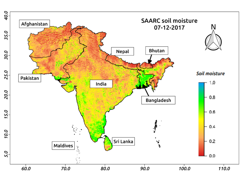
SAARC Charter day: Soil moisture using Satellite for SAARC nations

Posted on Posted in Agriculture, Algorithm Development, Crop insurance, Disaster Management, Geospatial Modelling, News, Satellite Remote Sensing, Water Resources

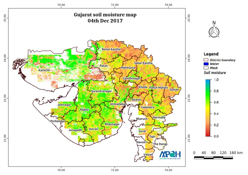
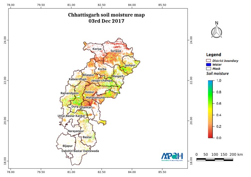
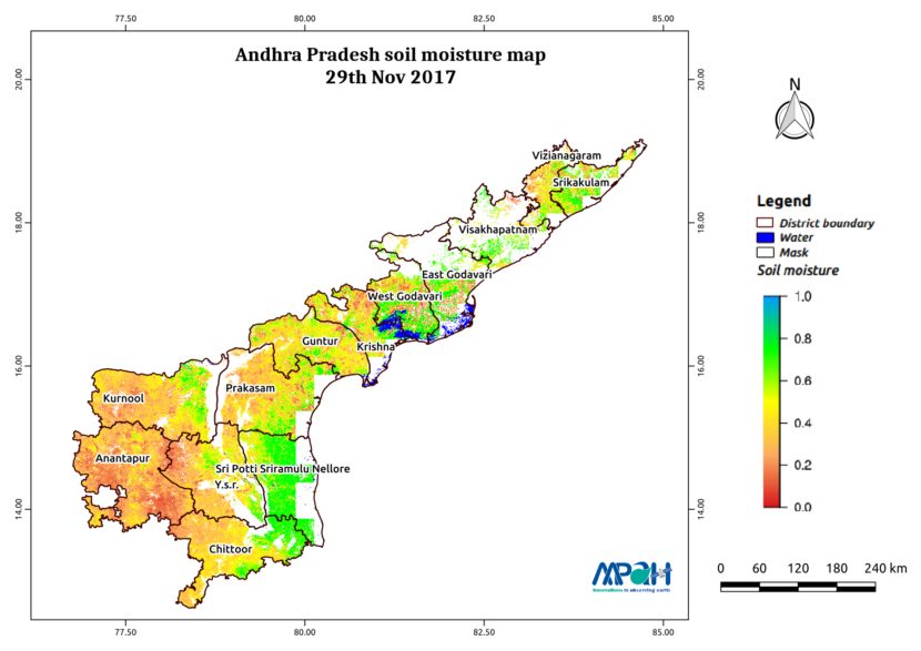
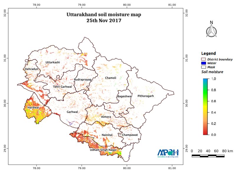
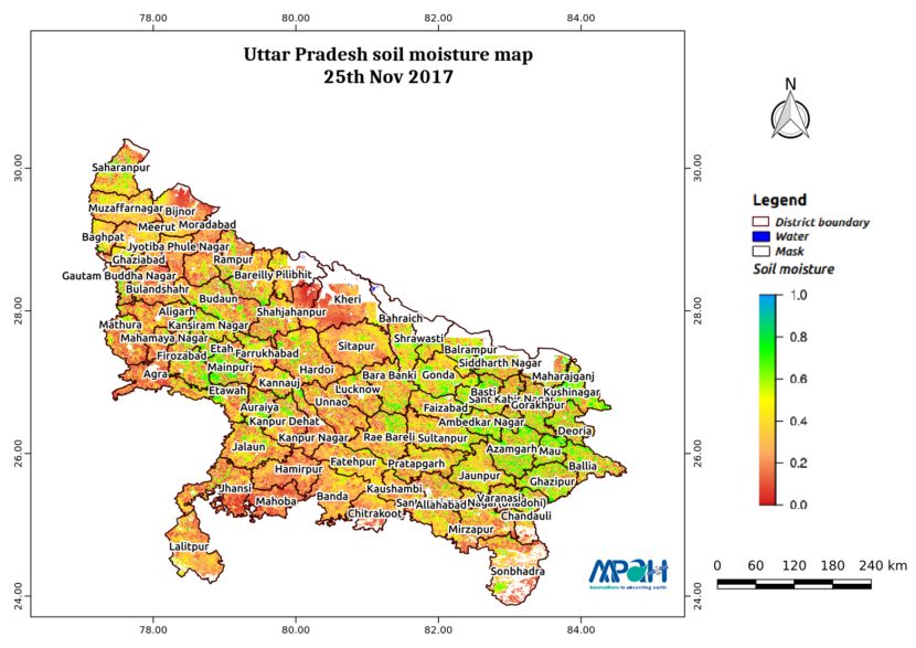
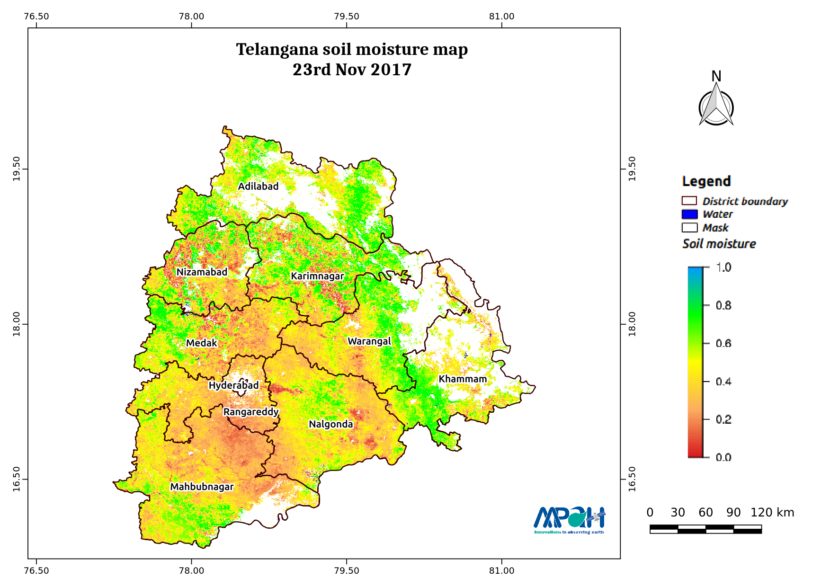
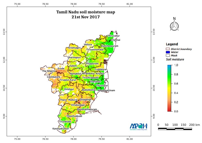
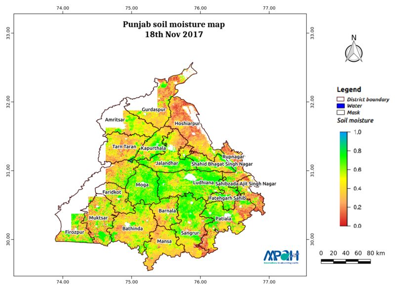
SAARC (South Asian Association for Regional Cooperation) was founded on 8th December, 1985. The member nations of this organization include Afghanistan, Bangladesh, Bhutan, India, Maldives, Nepal, Pakistan and Sri Lanka. To commemorate this 33rd SAARC Charter day, Aapah Innovations created high-resolution soil moisture map for SAARC using satellite data. Agriculture drought arises when soil moisture […]

Soil Moisture Map for the state of Gujarat

Posted on Posted in Agriculture, Algorithm Development, Disaster Management, Environment, News, Satellite Remote Sensing, Water Resources

The image shows the soil moisture map for Gujarat state. The map is prepared by merging microwave and optical satellite data using the algorithm developed by us. The soil moisture maps are available daily at a spatial resolution of 500 m. The developed near real time soil moisture is helpful for: Early warning of agricultural […]

Soil Moisture Map for the state of Chhattisgarh

Posted on Posted in Agriculture, Algorithm Development, Disaster Management, Environment, News, Satellite Remote Sensing, Water Resources

The image shows the soil moisture map for Chhattisgarh state. The map is prepared by merging microwave and optical satellite data using the algorithm developed by us. The soil moisture maps are available daily at a spatial resolution of 500 m. The developed near real time soil moisture is helpful for: Early warning of agricultural […]

Soil Moisture Map for the state of Andhra Pradesh

Posted on Posted in Agriculture, Algorithm Development, Disaster Management, Environment, News, Satellite Remote Sensing, Water Resources

The image shows the soil moisture map for Andhra Pradesh state. The map is prepared by merging microwave and optical satellite data using the algorithm developed by us. The soil moisture maps are available daily at a spatial resolution of 500 m. The developed near real time soil moisture is helpful for: Early warning of […]

Soil Moisture Map for the state of Uttarakhand

Posted on Posted in Agriculture, Algorithm Development, Disaster Management, Environment, News, Satellite Remote Sensing, Water Resources

The image shows the soil moisture map for Uttarakhand state. The map is prepared by merging microwave and optical satellite data using the algorithm developed by us. The soil moisture maps are available daily at a spatial resolution of 500 m. The developed near real time soil moisture is helpful for: Early warning of agricultural […]

Soil Moisture Map for the state of Uttar Pradesh

Posted on Posted in Agriculture, Algorithm Development, Disaster Management, Environment, News, Satellite Remote Sensing, Water Resources

The image shows the soil moisture map for Uttar Pradesh state. The map is prepared by merging microwave and optical satellite data using the algorithm developed by us. The soil moisture maps are available daily at a spatial resolution of 500 m. The developed near real time soil moisture is helpful for: Early warning of […]

Soil Moisture Map for the state of Telangana

Posted on Posted in Agriculture, Algorithm Development, Disaster Management, Environment, News, Satellite Remote Sensing, Water Resources

The image shows the soil moisture map for Telangana state. The map is prepared by merging microwave and optical satellite data using the algorithm developed by us. The soil moisture maps are available daily at a spatial resolution of 500 m. The developed near real time soil moisture is helpful for: Early warning of agricultural […]

Soil Moisture Map for the state of Tamil Nadu

Posted on Posted in Agriculture, Algorithm Development, Disaster Management, Environment, News, Satellite Remote Sensing, Water Resources

The image shows the soil moisture map for Tamil Nadu state. The map is prepared by merging microwave and optical satellite data using the algorithm developed by us. The soil moisture maps are available daily at a spatial resolution of 500 m. The developed near real time soil moisture is helpful for: Early warning of […]

Soil Moisture Map for the state of Punjab

Posted on Posted in Agriculture, Algorithm Development, Disaster Management, Environment, News, Satellite Remote Sensing, Water Resources

The image shows the soil moisture map for Punjab state. The map is prepared by merging microwave and optical satellite data using the algorithm developed by us. The soil moisture maps are available daily at a spatial resolution of 500 m. The developed near real time soil moisture is helpful for: Early warning of agricultural […]

Air quality monitoring in Delhi

Posted on Posted in News, Remote Sensing, satellite, Satellite Remote Sensing

Poor air quality is caused by motor vehicle emission, fires on agricultural land, dust from construction sites, burning garbage, industrial activities etc. Aapah innovations have been monitoring the air pollution in Delhi using remote sensing data. In this analysis, we used daily Aerosol Optical Thickness (AOT) at 0.55 micron, which was extracted from MODIS MOD04_3K […]