
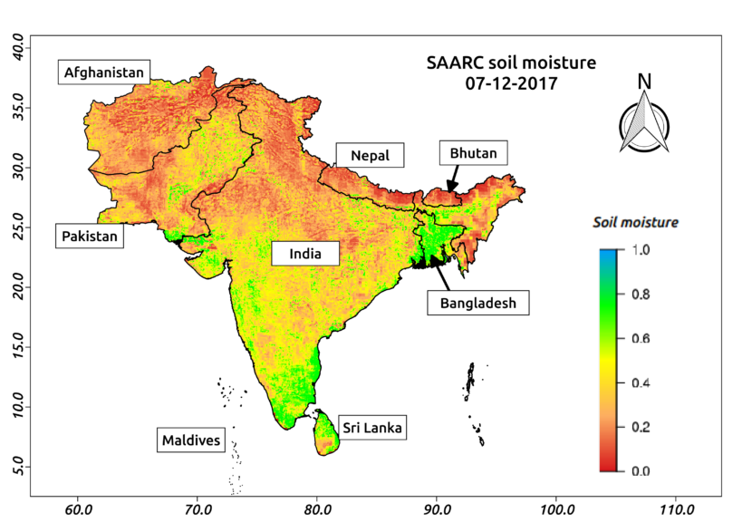
SAARC (South Asian Association for Regional Cooperation) was founded on 8th December, 1985. The member nations of this organization include Afghanistan, Bangladesh, Bhutan, India, Maldives, Nepal, Pakistan and Sri Lanka. To commemorate this 33rd SAARC Charter day, Aapah Innovations created high-resolution soil moisture map for SAARC using satellite data. Agriculture drought arises when soil moisture and rainfall are inadequate during the crop growing seasons and is quite common in South Asian countries. Above figure shows the soil moisture for SAARC nations on 7th December 2017. In this figure, soil moisture is prepared using the optical and passive microwave data at 500m spatial resolution with daily temporal frequency. The figure clearly shows high soil moisture in Bangladesh and Sri Lanka. The figure also shows that the soil moisture is comparatively low in Pakistan, Afghanistan, Nepal and Bhutan. Whereas in India, it is relatively high in South India and considerably low in other parts.
Aapah Innovations Pvt Ltd has developed an innovative algorithm to obtain soil moisture data at higher spatial and temporal resolution by combining the multi-satellite data.


Latest posts by Thiyaku S. (see all)
- Soil Moisture Map for the state of Kerala - February 13, 2018
- Soil Moisture Map for the state of Jharkhand - February 11, 2018
- Soil Moisture Map for the state of Haryana - February 8, 2018