


Tanks are an important source of irrigation. Artificial or natural, tanks are used for harvesting and preserving the local rainfall and water from streams and rivers for later use for various purposes including agriculture and domestic. For serving the purpose, tanks require regular maintenance, revival, and restoration which includes frequent removal of silt (desilting). Also, the breaches in tank bunds and supply channels due to excessive rainfall and floods have to be repaired promptly. Governments of many states run several schemes to rehabilitate tanks to fulfill their desired purpose e.g. Andhra Pradesh government which is running a community-based tank management project funded by World Bank and central Government ((http://www.apmitanks.in/)). In AP, there are 975 tanks under the project costing 459.20 crores in 200 mandals of 12 districts ((http://apmitanks.in/Templates/messages/minmsg.htm)). The major objective of the project is to enhance the agricultural productivity by minimizing the water deficit for crops.
Similarly, Government of Odisha in partnership with Government of India has initiated Odisha Community Tank Management Project ((http://www.octmp.nic.in/)) to repair and rehabilitate approximately 900 minor irrigation tanks having a command area of 40 ha to 2000 Ha and covering 1.20 lakh ha across the state of Odisha with funding from World Bank. The government of Telangana ((http://irrigation.telangana.gov.in/icad/minorReports)), Karnataka ((https://www.karnataka.gov.in/minorirrigation/aboutus.html)) and Tamilnadu ((http://www.iamwarm.gov.in/)) also works in many projects in this direction.
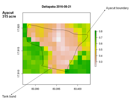
The question arises – how to monitor the impact of the rehabilitation on the tank? Traditionally identification of rehabilitated tanks was done by the manual method in which individual has to visit each of the physical sites where tanks are located. The problem arises when tanks exist in quite a large number and visiting each tank physically is almost impossible due to lack of resources. An alternate approach is to use remote sensing to map the soil moisture periodically to assess the water deficit for crops in ayacut. Above figure shows a soil moisture map for Dattapakka tank, Visakhapatnam district, Andhra Pradesh. The soil moisture map is prepared by Aapah innovations using microwave remote sensing data provided by European Space Agency. The soil moisture products are validated in different states in India and abroad. As can be seen from the figure, interestingly the soil moisture within the ayacut (command area) is low compared to outside ayacut. Does it mean the tank rehabilitation is not serving its purpose? To know the answer to such questions, contact Aapah Innovations.