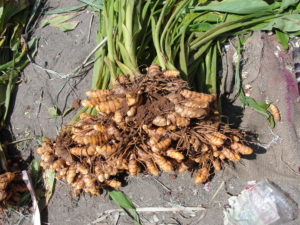
Want to know how Turmeric is growing in your area?
Advanced estimate of the crop yield is useful in various applications e.g. crop insurance, harvest planning, delivery estimates, etc. Advanced ...
Read More
Read More
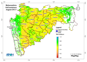
Did crop get enough water in Maharashtra this Kharif season?
The Kharif season is approaching its end and the availability of water to crops in Maharashtra using Satellite microwave remote ...
Read More
Read More
Mapping India’s farmland from space
In India, 72 % of the farmers hold less than 2 ha of land, out of which approximately two-third has ...
Read More
Read More

Weather Forecasting
The satellite soil moisture can provide the estimate of evaporation and transpiration. The information on the evaporation from the land ...
Read More
Read More
Integrated Water Management Programme (IWMP)
The primary objective of IWMP is to address the issue of soil degradation & moisture conservation in the rain-fed areas ...
Read More
Read More

Prediction of flood risk
The flood depends upon the intensity of rainfall and the infiltration (absorption) capacity of soil which is related to soil ...
Read More
Read More
Monitor agricultural drought using satellite data in near real time
A deficit in the available soil moisture for agriculture is termed as drought which results in the lack of crop ...
Read More
Read More
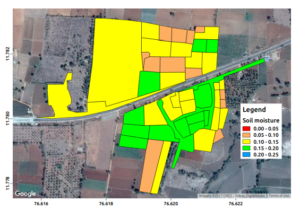
Village level soil moisture mapping using satellite data
Knowledge of higher spatial resolution soil moisture is of paramount importance in agriculture, water resource management, flood, drought, etc. Soil ...
Read More
Read More
Related News
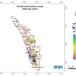
- Soil Moisture Map for the state of Kerala (2/13/2018) - The image shows the soil moisture map for Kerala state for 09-Feb-2018. The map is prepared by merging data from multiple satellites using the vikleda algorithm. Some of the applications where soil moisture is useful are: Optimal irrigation in farms Identify areas being over-irrigated Improved flood risk estimation Monitor agricultural drought in near real time […]
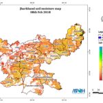
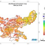
- Soil Moisture Map for the state of Jharkhand (2/11/2018) - The image shows the soil moisture map for Jharkhand state for 08-Feb-2018. The map is prepared by merging data from multiple satellites using the vikleda algorithm. Some of the applications where soil moisture is useful are: Optimal irrigation in farms Identify areas being over-irrigated Improved flood risk estimation Monitor agricultural drought in near real time […]
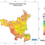
- Soil Moisture Map for the state of Haryana (2/8/2018) - The image shows the soil moisture map for Haryana state for 05-Feb-2018. The map is prepared by merging data from multiple satellites using the vikleda algorithm. Some of the applications where soil moisture is useful are: Optimal irrigation in farms Identify areas being over-irrigated Improved flood risk estimation Monitor agricultural drought in near real time […]
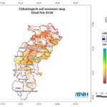
- Soil Moisture Map for the state of Chhattisgarh (2/5/2018) - The image shows the soil moisture map for Chhattisgarh state for 02-Feb-2018. The map is prepared by merging data from multiple satellites using the vikleda algorithm. Some of the applications where soil moisture is useful are: Optimal irrigation in farms Identify areas being over-irrigated Improved flood risk estimation Monitor agricultural drought in near real time […]
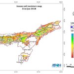
- Soil Moisture Map for the state of Assam (2/3/2018) - The image shows the soil moisture map for Assam state for 31-Jan-2018. The map is prepared by merging data from multiple satellites using the vikleda algorithm. Some of the applications where soil moisture is useful are: Optimal irrigation in farms Identify areas being over-irrigated Improved flood risk estimation Monitor agricultural drought in near real time […]
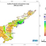
- Soil Moisture Map for the state of Andhra Pradesh (2/1/2018) - The image shows the soil moisture map for Andhra Pradesh state for 28-Jan-2018. The map is prepared by merging data from multiple satellites using the vikleda algorithm. Some of the applications where soil moisture is useful are: Optimal irrigation in farms Identify areas being over-irrigated Improved flood risk estimation Monitor agricultural drought in near real […]
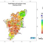
- Soil Moisture Map for the state of Tamil Nadu (1/24/2018) - The image shows the soil moisture map for Tamil Nadu state for 22-Jan-2018. The map is prepared by merging data from multiple satellites using the vikleda algorithm. Some of the applications where soil moisture is useful are: Optimal irrigation in farms Identify areas being over-irrigated Improved flood risk estimation Monitor agricultural drought in near real […]
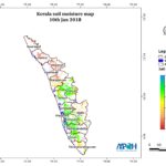
- Soil Moisture Map for the state of Kerala (1/13/2018) - The image shows the soil moisture map for Kerala state for 10-Jan-2018. The map is prepared by merging data from multiple satellites using the vikleda algorithm. Some of the applications where soil moisture is useful are: Optimal irrigation in farms Identify areas being over-irrigated Improved flood risk estimation Monitor agricultural drought in near real time […]
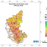
- Soil Moisture Map for the state of Karnataka (1/12/2018) - The image shows the soil moisture map for Karnataka state for 09-Jan-2018. The map is prepared by merging data from multiple satellites using the vikleda algorithm. Some of the applications where soil moisture is useful are: Optimal irrigation in farms Identify areas being over-irrigated Improved flood risk estimation Monitor agricultural drought in near real time […]
- Soil Moisture Map for the state of Jharkhand (1/11/2018) - The image shows the soil moisture map for Jharkhand state for 08-Jan-2018. The map is prepared by merging data from multiple satellites using the vikleda algorithm. Some of the applications where soil moisture is useful are: Optimal irrigation in farms Identify areas being over-irrigated Improved flood risk estimation Monitor agricultural drought in near real time […]